|
pktools
2.6.7
Processing Kernel for geospatial data
|
|
pktools
2.6.7
Processing Kernel for geospatial data
|
#include <ImgRasterGdal.h>
Public Member Functions | |
| ImgRasterGdal (void) | |
| default constructor | |
| virtual | ~ImgRasterGdal (void) |
| destructor | |
| void | setScale (double theScale, int band=0) |
| Set scale for a specific band when writing the raster data values. The scaling and offset are applied on a per band basis. You need to set the scale for each band. | |
| void | setOffset (double theOffset, int band=0) |
| Set offset for a specific band when writing the raster data values. The scaling and offset are applied on a per band basis. You need to set the offset for each band. | |
| virtual void | close (void) |
| Close the image. | |
| std::string | getFileName () const |
| Get the filename of this dataset. | |
| int | nrOfCol (void) const |
| Get the number of columns of this dataset. | |
| int | nrOfRow (void) const |
| Get the number of rows of this dataset. | |
| int | nrOfBand (void) const |
| Get the number of bands of this dataset. | |
| bool | isGeoRef () const |
| Is this dataset georeferenced (pixel size in y must be negative) ? | |
| std::string | getProjection (void) const |
| Get the projection string (deprecated, use getProjectionRef instead) More... | |
| std::string | getProjectionRef (void) const |
| Get the projection reference. More... | |
| std::string | getGeoTransform () const |
| Get the geotransform data for this dataset as a string. More... | |
| void | getGeoTransform (double *gt) const |
| Get the geotransform data for this dataset. More... | |
| CPLErr | setGeoTransform (double *gt) |
| Set the geotransform data for this dataset. More... | |
| void | copyGeoTransform (const ImgRasterGdal &imgSrc) |
| Copy geotransform information from another georeferenced image. More... | |
| CPLErr | setProjection (const std::string &projection) |
| Set the projection for this dataset in well known text (wkt) format. More... | |
| CPLErr | setProjectionProj4 (const std::string &projection) |
| Set the projection for this dataset from user input (supports epsg:<number> format) More... | |
| bool | getBoundingBox (double &ulx, double &uly, double &lrx, double &lry) const |
| Get the bounding box of this dataset in georeferenced coordinates. More... | |
| bool | getCenterPos (double &x, double &y) const |
| Get the center position of this dataset in georeferenced coordinates. More... | |
| double | getUlx () const |
| Get the upper left corner x (georeferenced) coordinate of this dataset. | |
| double | getUly () const |
| Get the upper left corner y (georeferenced) coordinate of this dataset. | |
| double | getLrx () const |
| Get the lower right corner x (georeferenced) coordinate of this dataset. | |
| double | getLry () const |
| Get the lower right corner y (georeferenced) coordinate of this dataset. | |
| int | getNoDataValues (std::vector< double > &noDataValues) const |
| Get the no data values of this dataset as a standard template library (stl) vector. More... | |
| bool | isNoData (double value) const |
| Check if value is nodata in this dataset. | |
| int | pushNoDataValue (double noDataValue) |
| Push a no data value for this dataset. More... | |
| int | setNoData (const std::vector< double > nodata) |
| Set the no data values of this dataset using a standard template library (stl) vector as input. | |
| CPLErr | GDALSetNoDataValue (double noDataValue, int band=0) |
| Set the GDAL (internal) no data value for this data set. Only a single no data value per band is supported. | |
| bool | covers (double x, double y) const |
| Check if a geolocation is covered by this dataset. Only the bounding box is checked, irrespective of no data values. More... | |
| bool | covers (double ulx, double uly, double lrx, double lry) const |
| Check if a region of interest is (partially) covered by this dataset. Only the bounding box is checked, irrespective of no data values. More... | |
| bool | geo2image (double x, double y, double &i, double &j) const |
| Convert georeferenced coordinates (x and y) to image coordinates (column and row) More... | |
| bool | image2geo (double i, double j, double &x, double &y) const |
| Convert image coordinates (column and row) to georeferenced coordinates (x and y) More... | |
| double | getDeltaX (void) const |
| Get the pixel cell spacing in x. | |
| double | getDeltaY (void) const |
| Get the pixel cell spacing in y. | |
| GDALDataType | getDataType (int band=0) const |
| Get the GDAL datatype for this dataset. More... | |
| GDALRasterBand * | getRasterBand (int band=0) const |
| Get the GDAL rasterband for this dataset. More... | |
| GDALColorTable * | getColorTable (int band=0) const |
| Get the GDAL color table for this dataset as an instance of the GDALColorTable class. More... | |
| std::string | getDriverDescription () const |
| Get the GDAL driver description of this dataset. More... | |
| std::string | getImageType () const |
| Get the image type (implemented as the driver description) | |
| std::string | getInterleave () const |
| Get the band coding (interleave) More... | |
| std::string | getCompression () const |
| Get the compression from the metadata of this dataset. More... | |
| GDALDataset * | getDataset () |
| char ** | getMetadata () |
| Get the metadata of this dataset. More... | |
| char ** | getMetadata () const |
| Get the metadata of this dataset (const version) More... | |
| void | getMetadata (std::list< std::string > &metadata) const |
| Get the metadata of this dataset in the form of a list of strings (const version) More... | |
| std::string | getDescription () const |
| Get the image description from the driver of this dataset. More... | |
| std::string | getMetadataItem () const |
| Get metadata item of this dataset. More... | |
| std::string | getImageDescription () const |
| Get the image description from the metadata of this dataset. More... | |
| int | nrOfBlockX (int band=0) |
| int | nrOfBlockY (int band=0) |
Protected Attributes | |
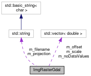
| std::string | m_filename |
| filename of this dataset | |
| GDALDataset * | m_gds |
| instance of the GDAL dataset of this dataset | |
| int | m_ncol |
| number of columns in this dataset | |
| int | m_nrow |
| number of rows in this dataset | |
| int | m_nband |
| number of bands in this dataset | |
| GDALDataType | m_dataType |
| GDAL data type for this dataset. | |
| double | m_gt [6] |
| geotransform information of this dataset | |
| std::string | m_projection |
| std::vector< double > | m_noDataValues |
| no data values for this dataset | |
| std::vector< double > | m_scale |
| Vector containing the scale factor to be applied (one scale value for each band) | |
| std::vector< double > | m_offset |
| Vector containing the offset factor to be applied (one offset value for each band) | |
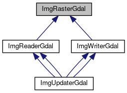
Friends | |
| class | ImgReaderGdal |
| class | ImgWriterGdal |
Base class for raster dataset (read and write) in a format supported by GDAL. This general raster class is used to store e.g., filename, number of columns, rows and bands of the dataset.
Definition at line 67 of file ImgRasterGdal.h.
| void ImgRasterGdal::copyGeoTransform | ( | const ImgRasterGdal & | imgSrc | ) |
Copy geotransform information from another georeferenced image.
| imgSrc | Use this source image as a template to copy geotranform information |
Definition at line 166 of file ImgRasterGdal.cc.
| bool ImgRasterGdal::covers | ( | double | x, |
| double | y | ||
| ) | const |
Check if a geolocation is covered by this dataset. Only the bounding box is checked, irrespective of no data values.
assuming adfGeotransform[0]: ULX (upper left X coordinate) adfGeotransform[1]: $cos(){Xres}$ adfGeotransform[2]: $-sin(){Xres}$ adfGeotransform[3]: ULY (upper left Y coordinate) adfGeotransform[4]: $-sin(){Yres}$ adfGeotransform[5]: $-cos(){Yres}$
| x,y | georeferenced coordinates in x and y |
Definition at line 443 of file ImgRasterGdal.cc.
| bool ImgRasterGdal::covers | ( | double | ulx, |
| double | uly, | ||
| double | lrx, | ||
| double | lry | ||
| ) | const |
Check if a region of interest is (partially) covered by this dataset. Only the bounding box is checked, irrespective of no data values.
assuming adfGeotransform[0]: ULX (upper left X coordinate) adfGeotransform[1]: $cos(){Xres}$ adfGeotransform[2]: $-sin(){Xres}$ adfGeotransform[3]: ULY (upper left Y coordinate) adfGeotransform[4]: $-sin(){Yres}$ adfGeotransform[5]: $-cos(){Yres}$
| ulx | upper left coordinate in x |
| uly | upper left coordinate in y |
| lrx | lower left coordinate in x |
| lry | lower left coordinate in y |
Definition at line 467 of file ImgRasterGdal.cc.
| bool ImgRasterGdal::geo2image | ( | double | x, |
| double | y, | ||
| double & | i, | ||
| double & | j | ||
| ) | const |
Convert georeferenced coordinates (x and y) to image coordinates (column and row)
assuming adfGeotransform[0]: ULX (upper left X coordinate) adfGeotransform[1]: $cos(){Xres}$ adfGeotransform[2]: $-sin(){Xres}$ adfGeotransform[3]: ULY (upper left Y coordinate) adfGeotransform[4]: $-sin(){Yres}$ adfGeotransform[5]: $-cos(){Yres}$
| x,y | georeferenced coordinates in x and y |
| i,j | image coordinates (can be fraction of pixels) |
Definition at line 387 of file ImgRasterGdal.cc.
| bool ImgRasterGdal::getBoundingBox | ( | double & | ulx, |
| double & | uly, | ||
| double & | lrx, | ||
| double & | lry | ||
| ) | const |
Get the bounding box of this dataset in georeferenced coordinates.
assuming adfGeotransform[0]: ULX (upper left X coordinate) adfGeotransform[1]: $cos(){Xres}$ adfGeotransform[2]: $-sin(){Xres}$ adfGeotransform[3]: ULY (upper left Y coordinate) adfGeotransform[4]: $-sin(){Yres}$ adfGeotransform[5]: $-cos(){Yres}$
| ulx | upper left coordinate in x |
| uly | upper left coordinate in y |
| lrx | lower left coordinate in x |
| lry | lower left coordinate in y |
Definition at line 333 of file ImgRasterGdal.cc.
| bool ImgRasterGdal::getCenterPos | ( | double & | x, |
| double & | y | ||
| ) | const |
Get the center position of this dataset in georeferenced coordinates.
assuming adfGeotransform[0]: ULX (upper left X coordinate) adfGeotransform[1]: $cos(){Xres}$ adfGeotransform[2]: $-sin(){Xres}$ adfGeotransform[3]: ULY (upper left Y coordinate) adfGeotransform[4]: $-sin(){Yres}$ adfGeotransform[5]: $-cos(){Yres}$
| x,y | centre coordinates in x and y |
Definition at line 359 of file ImgRasterGdal.cc.
| GDALColorTable * ImgRasterGdal::getColorTable | ( | int | band = 0 | ) | const |
Get the GDAL color table for this dataset as an instance of the GDALColorTable class.
| band | get GDAL color table for this band (start counting from 0) |
Definition at line 118 of file ImgRasterGdal.cc.
| std::string ImgRasterGdal::getCompression | ( | ) | const |
Get the compression from the metadata of this dataset.
Definition at line 308 of file ImgRasterGdal.cc.
| GDALDataType ImgRasterGdal::getDataType | ( | int | band = 0 | ) | const |
Get the GDAL datatype for this dataset.
| band | get data type for this band (start counting from 0) |
Definition at line 92 of file ImgRasterGdal.cc.
| std::string ImgRasterGdal::getDescription | ( | ) | const |
Get the image description from the driver of this dataset.
Definition at line 254 of file ImgRasterGdal.cc.
| std::string ImgRasterGdal::getDriverDescription | ( | ) | const |
Get the GDAL driver description of this dataset.
Definition at line 131 of file ImgRasterGdal.cc.
| std::string ImgRasterGdal::getGeoTransform | ( | ) | const |
Get the geotransform data for this dataset as a string.
Definition at line 200 of file ImgRasterGdal.cc.
| void ImgRasterGdal::getGeoTransform | ( | double * | gt | ) | const |
Get the geotransform data for this dataset.
| gt | pointer to the six geotransform parameters: |
| adfGeoTransform[0] | top left x |
| GeoTransform[1] | w-e pixel resolution |
| GeoTransform[2] | rotation, 0 if image is "north up" |
| GeoTransform[3] | top left y |
| GeoTransform[4] | rotation, 0 if image is "north up" |
| GeoTransform[5] | n-s pixel resolution |
Definition at line 183 of file ImgRasterGdal.cc.
| std::string ImgRasterGdal::getImageDescription | ( | ) | const |
Get the image description from the metadata of this dataset.
Definition at line 280 of file ImgRasterGdal.cc.
| std::string ImgRasterGdal::getInterleave | ( | ) | const |
Get the band coding (interleave)
Definition at line 293 of file ImgRasterGdal.cc.
| char ** ImgRasterGdal::getMetadata | ( | ) |
Get the metadata of this dataset.
Definition at line 214 of file ImgRasterGdal.cc.
| char ** ImgRasterGdal::getMetadata | ( | ) | const |
Get the metadata of this dataset (const version)
Definition at line 227 of file ImgRasterGdal.cc.
| void ImgRasterGdal::getMetadata | ( | std::list< std::string > & | metadata | ) | const |
Get the metadata of this dataset in the form of a list of strings (const version)
Definition at line 240 of file ImgRasterGdal.cc.
| std::string ImgRasterGdal::getMetadataItem | ( | ) | const |
Get metadata item of this dataset.
Definition at line 267 of file ImgRasterGdal.cc.
| int ImgRasterGdal::getNoDataValues | ( | std::vector< double > & | noDataValues | ) | const |
Get the no data values of this dataset as a standard template library (stl) vector.
| noDataValues | standard template library (stl) vector containing no data values |
Definition at line 478 of file ImgRasterGdal.cc.
| std::string ImgRasterGdal::getProjection | ( | void | ) | const |
Get the projection string (deprecated, use getProjectionRef instead)
Definition at line 40 of file ImgRasterGdal.cc.
| std::string ImgRasterGdal::getProjectionRef | ( | void | ) | const |
Get the projection reference.
Definition at line 51 of file ImgRasterGdal.cc.
| GDALRasterBand * ImgRasterGdal::getRasterBand | ( | int | band = 0 | ) | const |
Get the GDAL rasterband for this dataset.
| band | get GDAL raster band for this band (start counting from 0) |
Definition at line 105 of file ImgRasterGdal.cc.
| bool ImgRasterGdal::image2geo | ( | double | i, |
| double | j, | ||
| double & | x, | ||
| double & | y | ||
| ) | const |
Convert image coordinates (column and row) to georeferenced coordinates (x and y)
assuming adfGeotransform[0]: ULX (upper left X coordinate) adfGeotransform[1]: $cos(){Xres}$ adfGeotransform[2]: $-sin(){Xres}$ adfGeotransform[3]: ULY (upper left Y coordinate) adfGeotransform[4]: $-sin(){Yres}$ adfGeotransform[5]: $-cos(){Yres}$
| i,j | image coordinates (can be fraction of pixels) |
| x,y | georeferenced coordinates in x and y (can be fraction of pixels) |
Definition at line 416 of file ImgRasterGdal.cc.
| int ImgRasterGdal::pushNoDataValue | ( | double | noDataValue | ) |
Push a no data value for this dataset.
| noDataValue | no data value to be pushed for this dataset |
Definition at line 492 of file ImgRasterGdal.cc.
| CPLErr ImgRasterGdal::setGeoTransform | ( | double * | gt | ) |
Set the geotransform data for this dataset.
| gt | pointer to the six geotransform parameters: |
| adfGeoTransform[0] | top left x |
| GeoTransform[1] | w-e pixel resolution |
| GeoTransform[2] | rotation, 0 if image is "north up" |
| GeoTransform[3] | top left y |
| GeoTransform[4] | rotation, 0 if image is "north up" |
| GeoTransform[5] | n-s pixel resolution |
Definition at line 148 of file ImgRasterGdal.cc.
| CPLErr ImgRasterGdal::setProjection | ( | const std::string & | projection | ) |
Set the projection for this dataset in well known text (wkt) format.
| projection | projection string to be used for this dataset |
Definition at line 79 of file ImgRasterGdal.cc.
| CPLErr ImgRasterGdal::setProjectionProj4 | ( | const std::string & | projection | ) |
Set the projection for this dataset from user input (supports epsg:<number> format)
| projection | projection string to be used for this dataset |
Definition at line 63 of file ImgRasterGdal.cc.
 1.8.13